Geography and Climate
CONTACT US: sales@viaturtravel.net / (506) 2296-1024
![]()
The Key to your Adventurous Travel!
T (506) 2296-1024
Email: sales@viaturtravel.net
Viatur Travel Services
Rohrmoser, San Jose Costa Rica 394-1000
Geography
Costa Rica's Geography
Costa Rica is located in the tropics and is bordered to the North by Nicaragua, to the South by Panama, to the West by the Pacific Ocean and to the East by the Caribbean.
Longitude: 83-86°; latitude: 8-11°.
The country covers 51,100 sq. km., similar in size to Denmark.
There is a series of volcanic mountain chains, which runs from the northwest border to the southeast border, splitting the country into two regions. Highest elevation is 3,810 meters. In the center of these ranges is a Central Valley or high-altitude plain, with coastal lowlands on either side. Over half of the population lives on this plain, with San José, the Capital, as the main city.
Population
Costa Rica counts with app. 4.2 mln inhabitants of which app. 900,000 people live in San José.
Climate
Costa Rica's Climate
The dry season, or verano (summer), is from mid December to April. Invierno (winter) or also known as ‘green season’ lasts the rest of the year and brings sunny mornings and rainy afternoons.
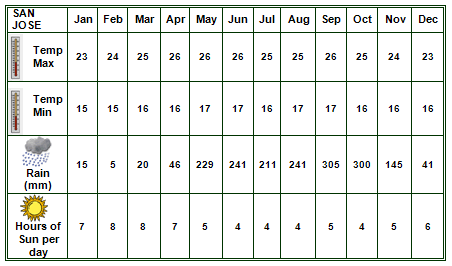
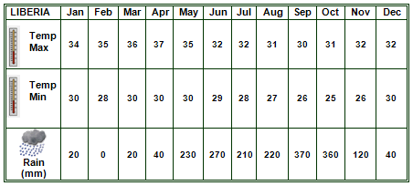
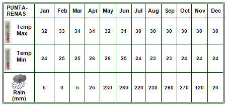
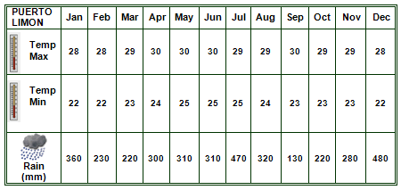
Here we present an overview of the Costa Rican climate from coast to coast.
Central Valley
Guanacaste
Puntarenas
Limón

All pictures belong to Viatur private collections and are subject to ©.
Powered by Programática Web Studio © 2026. All rights reserved.